31 December, 2019

Happy New Year and Where Are We Now?

Location: Radford, Virginia, US


Wow! A lot has happened in the months since last April when we last wrote. Here's the end-of-the-year synopsis, "Readers Digest" style:

A giant cowboy we saw on the way home. 


We made it safely back to Blacksburg in late March.
 Kentucky Easter decorations
Our new 18' travel trailer 

We decide to sell "No Sails", take our house off rental market in August, and move back in again, at least for a while. But we need to have somewhere to live until August if we sell the View. So we buy a pickup truck and an 18' travel trailer. Now we can put "No Sails" on the market. Except that we've missed that spring time "sellers market". So we wait. And wait. And wait longer. And keep waiting. Move into our house on 2 August – now we have three homes and two vehicles. So, sad to say, we decide to sell Wanda the Honda, too. She sells quickly and we miss her. Finally "No Sails" sells in mid August. Phew!! Back down to 1 vehicle and 1 camper again.


 Rotator cuff surgery recovery


Then we change our minds and decide to put the Blacksburg house back on the rental market for the income, and start searching for a smaller, less expensive house we can use as a "home base" while continuing to travel. After looking for several months, we eventually hit paydirt and find a little one-bedroom house in nearby Radford that we love.


 Our little new house
 A bucket of giant shrimp in Beaufort, North Carolina
 Pilot Mountain, North Carolina
 Hiking Pilot Mountain
 Our Christmas tree


So, where are we now? Radford for the holidays, doing house jobs, building a Murphy bed for when we have guests, and deciding where we'll go when we can't stand the cold later this winter – Puerto Rico, Spain and Mexico have been mentioned. Then we're thinking about taking the camper out to Montana and New Mexico for a large chunk of next summer. Time'll tell ...

Working on the Murphy bed
The Murphy bed


Hope you had a wonderful Christmas, and are, like us, looking forward to the New Year!


10 April, 2019

The Green Dots


Location: Lake Mohave, Nevada


We've had a wonderful 3 week visit with one of our sons (and some great friends) near Redding, California. Apparently, we've been having so much fun (and are soo slack) that we've forgotten to take any pictures!! And now it's too late as it's time for us to say goodbye and start wending our way back to Virginia.

We've had several discussions about which route to take but, after several false starts, it all comes down to what the weather is doing when it was time to leave. Shades of sailing on Rachel, eh?

One of the few things we do know is that we want to stay, as much as possible, on "the green dots". They mark "scenic routes" as defined by our maps. Once we pick the general direction we want to head, we then look for the green dots in various resources and try to spend most of our time following them, as long as we're not getting too far off our track ("too far" being about as undefined and flexible as possible).

April is not the best time to be traveling across the US as there is still snow in the north and high winds, rain, and tornadoes in the middle and south. The upside, however, is that the prevailing winds are from west to east, so we're hoping to get a bit of a tailwind for at least part of the way.

We are a bit late leaving as we we've been waiting for some parts for a last minute repair. Three days before our departure we start poring over the big picture weather charts. The northern route is definitely out! Too much snow and too cold – we're sick of being cold after this last winter in the southwest.

What about Interstate through Colorado, that would be beautiful? Nope, elevation is too high for too far and still too much snow!

Sheesh. Well, how about dropping down through Arizona/New Mexico/and the Texas panhandle? That looks pretty clear, and we don't want to go the southern route as we came out that way – we want to see new stuff!

Now which way should we start out? The best forecast is down the west side of the Sierra Nevada mountains, but we've already made that trip so many times and it's NOT all that scenic. Julie really wanted to take California Rte 395 when we came up to Dan's but it was too snowy back in March. Let's check it out now. Ooh! The roads are clear and no snow is forecast! Great – things are coming together. Ok, looks like we finally have a plan!

Oh, wait. We'll still have to go over Donner Pass east of Sacramento which is 7,000 ft above sea level and there's still 10ft of snow up there!! But the interstate is clear and if it's a clear day we should be fine – we definitely won't be spending the night up there <brrr>.

There is rain forecast for the next 2 days with potential snow up at Donner. So we leave just before the rain and find a campground at only 2,000 ft elevation to stage for getting over the pass and down Rte 395 in 1 day – between this rain and before the next cold front.

Bear River Campground is perfect. Unfortunately, (of course!!) the weather forecast changes for the day we're going to traverse the pass and they're now predicting a slight chance of snow and slush up there. Even so, it's still the best travel day. So we wake up early, check the dept of transportation website...no snow...great - off we go!


 The drive is spectacular, up and over Donner Pass, where in 1846 a group of 81 settlers trying to reach California got stranded on the east side of the pass due to early snow. They were forced to spend the winter there and only 45 survived (cannibalism was involved). We don't want that to happen to us, and, luckily, it doesn't. Whew.


 We turn off the interstate at Lake Tahoe and follow Rte 395 south for 250 miles following the eastern side of the Sierra Nevada mountains. It is absolutely spectacular – it's slightly overcast, but with the snow-capped mountains, beautiful vistas, and a long gradual downhill run with a tailwind we can't ask for a better trip! We stop for the night at a BLM campground at 3,000 feet elevation and have a nice quiet, cool night – great sleeping weather and we don't get the plague!!

 The next day we head down to Death Valley. Another long downhill run (with a few pretty steep uphill bits), also outstanding. We're below sea level, wearing shorts and tee shirts, and are loving it!


 Day 3's highlight is a visit to the Hoover Dam, built in the 1930s on the Colorado River. Very impressive, and very art deco-ey.


Now we're in Lower Cottonwood Campground, a small National Park Service campground on Lake Mohave. We've been sitting here for two days and will be here for one more while high winds blow themselves out. We're as snug as a bug in a rug, tucked in behind a few trees and in between small, steep hills on three sides with the RV facing northwest into the wind – just like the old days on Rachel! We're getting some puffs and gusts, but nothing like we find on our walks outside the protection of our camp site where we have to lean into the wind to make progress. We definitely don't want to be out there driving the RV in 25-35 mph sustained gusting to 50 mph winds!

We know we won't have such stupendous scenery for much longer, and probably won't have such great luck with the weather for the remaining 2,100 miles back to Virginia. But as we sit here cuddled up together sharing a glass of wine, looking over the maps, and planning the next stage of our trip, we are thankful for such a great "greet dots" start.

27 February, 2019

Anza-Borrego Redux


Location: Borrego Springs, California

As we weren't too far away, and had had SO much fun on our last visit, we decided to stop at Borrego Springs again. Three years ago we paid our first visit to Anza-Borrego State Park during the Swainson's Hawk migration and the flowering cactii and some wild flowers (see here).


 This time it's all flowers, flowers, and more flowers. We just happened to arrive as the wildflowers were in prime bloomage, but before it had hit the news and social media. What perfect timing – we beat the "flowergeddon" crowds (see here), and were able to spend a lot of time out wandering almost alone in the desert viewing this year's "superbloom". The flowers were amazing.


We also hiked through two slot canyons - "South Palm Wash Slot" and "The Slot" - that were both spectacular but also very different! There was lots of scrambling and squeezing through these very narrow high sided canyons.


To top it all off, we saw our second lenticular cloud ever, and – guess what? Our first was right here almost 3 years ago!
Our next-to-last stop was also one of our favorites, a small primitive campground on the shore of Lake Mohave on the Colorado River.  We spent a few days here hiking up into the beautiful canyon.


We are currently in Redding, California visiting our son, Dan, before starting the trek back east to Virginia in April.


26 February, 2019

The Rest of Texas and On To Arizona

Location: Bureau of Land Management (BLM) free camping near Yuma, Arizona

This was our first trip to Texas and we've really seen a lot of interesting things. The weather could have been warmer and sunnier at times, but other than that we can't complain. Overall we've had a great trip and have at times been pleasantly surprised, too. Here are a few highlights from our last 6 weeks

Merpig


We'll start by picking back up in the Texas Hill Country where we last left off. After our highly enjoyable visits to Gruene Hall, we headed out to the Lyndon B. Johnson State Historic Site in Johnson City, TX. The visitor center had tidbits of information we had never heard anywhere else, including a wonderful short documentary about the Pedernales River (apparently pronounced "perd-n-alice") starring President Lyndon B and First Lady "Lady Bird" Johnson.

There's also a living history area which we loved. It was very hands on. They even had a Sears catalog from the early 1900s which you could flip through – great stuff at incredible prices <g>. The docent was busy making his lunch on the wood stove, and chatted away with us about life back then and how the garden was doing etc. They usually get 4 harvests of vegetables a year due to the mild climate. Not so mild this year, though, as they'd just had a freeze.


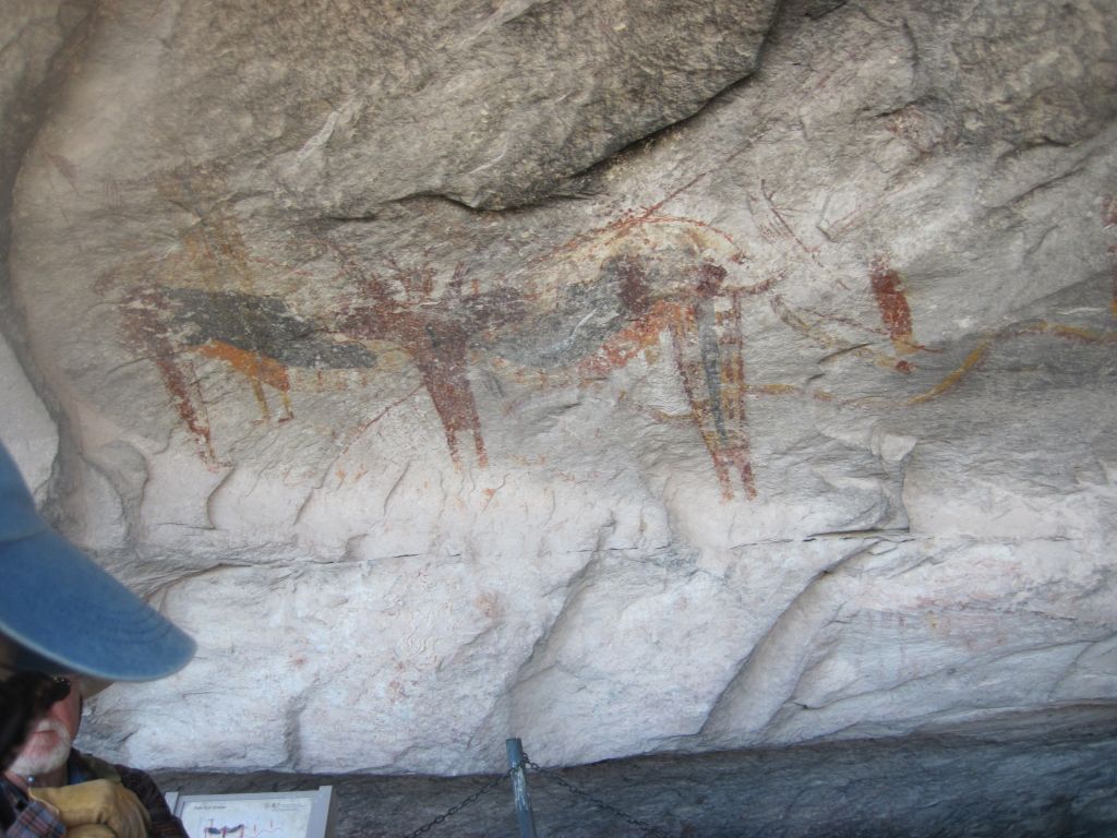
Mark butting heads with a buffalo


 Driving through the hill country was spectacular. Lots of evidence of the Germans who settled here in the early 20th century, as well as some of our favorite landscapes in Texas.


It was "bird city" at Garner State Park while we were there. We saw bluebirds, chickadees, red bellied woodpeckers, goldfinches, and many others flitting about in the branches of the trees around our campsite. One bluebird in particular kept fighting with itself in the RV side mirrors. He'd perch on top of the mirror, bend down, see his reflection, and start pecking at it. He even carried out the occasional arial attack, too, trying to get a jump on himself. We'd wake up in the morning to this strange clicking tapping noise and say "it's that stupid bluebird, again". We're not sure who eventually won, but there was a bit of bird poo cleanup required by the time he was finished.

Many of the buildings here were built by the Civilian Conservation Corp during in the 1930s. We especially liked the outdoor dance floor completed in 1941. It was built so the CCC guys could invite the townspeople out for regular Saturday night dances (Mark thinks the main reason for this was to get the local girls over to the camp!) At any rate, a dance is still held here every summer night (weather permitting) with music provided either by local bands or the venerable jukebox. What a great tradition! 


Our next stop was Seminole Canyon State Park. Visitors are not allowed to go down into the canyon without a guide, so we signed up for a guided tour (along with about 8 other people) scheduled for the following morning. A short hike down into the canyon and along the canyon floor, was followed by a climb up into two different large areas where over many, many years the river had undercut the walls of the canyon. Indigenous people lived in these caves and left behind many beautiful works of art drawn on the walls. Thanks to our two knowledgeable guides, it was a very interesting and informative tour.


As we headed further West, we became more and more aware that this part of the state is VERY remote. Many of the towns are over 50 miles apart (resulting in very limited cell phone service for the most part). We rely pretty heavily on our smartphone to do research about where to go, where to stay, and what things we might want to see along the way. Of course, we also use it to stay in touch with family and friends. At any rate, as we realized that our phone had beome unreliable, we were also mildly surprised to see how much we really missed having all that communication and info at our beck and call. A far cry from being on the boat in the middle of the ocean with only the radio for communication!

We'd been dawdling hoping that the government shut down would end because we really wanted to go to Big Bend National Park. We always like going to national park visitor's centers, watching whatever films they have, and talking to the rangers to learn what not to miss and what their favorite trails are. We finally decided to go anyway and it turned out to be fine. Due to the shutdown, attendance was low (one benefit, anyway) and we really enjoyed the trails and the scenery, just no Visitors Centres were open and no park rangers to talk to, and no cell phone signal. It's right on the Mexican border and one of the most remote national parks we've visited.

At Boquillas Canyon we found Mexican walking sticks, made from sotol cactus stems, beaded trinkets and embroidered items for sale on the honour system. "Put de mony en ken." Julie bought a walking stick – very light and strong.


Rio Grande


Our favourite trail was the Lost Mine trail, a 4.2 mile out-and-back hike. Walking the steady uphill switchback-laden grade all the way to the top (1,099 feet of elevation gain) we were rewarded with stunning panoramic views. We had nice, intermittent shade, cool light breezes, and a clear blue sky – couldn't have asked for better weather or a prettier walk. And, luckily, despite the warning signs, we didn't see any bears or mountain lions.


After we left Big Bend and were near the town of Marfa, Texas, Julie, idly gazing up at the sky as she is wont to do, spotted something white. "It looks like a balloon." As we got 10 miles closer, we thought it might be a hot air balloon. After 10 more miles we could tell that it was actually more of a dirigible – but a strange looking one – all white, no windows, no apparent motors, hmmm.... Then, as we passed under it, we noticed it was connected to the ground and saw a building and sign that said "Tethered Aerostat Radar System". The next time we had a cell signal we learned that these low-level "aerostats" provide radar surveillance for the drug interdiction program along the US / Mexican border. Pretty cool seeing our tax dollars at work. See https://en.wikipedia.org/wiki/Tethered_Aerostat_Radar_System for more info.


We'd traveled over 2,100 miles in Texas and still had not had any Texas famous BBQ. So when we got to El Paso on the western border we did some research (our cell phone works again – yay!!) and went to a highly reviewed 'genuine' Texas BBQ spot named Desert Oak BBQ. What a treat - it was fantastic! On the one hand, we're sorry we waited so long to try it, but on the other, we're really glad we did, as the Desert Oak's BBQ is absolutely delicious!


We finally made it to Arizona on January 28th and stayed at the Gilbert Ray county campground near Tucson where we were treated to great sunsets and lovely hikes.


 At the Sonora Desert Museum, one of the highlights of the Tucson area, we got to see lots of native animals and plants and had lots of great docents to explain and share lots of information.
Julie going batty!


We even got to see a live raptor show featuring about a dozen hawks zooming over our heads and landing and being fed by their handlers. We were pretty tired after spending the whole day at the museum!


Not really worth the cost of the sign!!


Los Aldogones, Mexico, also known as "Molar City" is an active hub of dental, optical, and pharmaceutical activity, just south and west of Yuma, Arizona. With reportedly over 350 dentists, 100 opticians, and loads of pharmacies, North Americans flock there for inexpensive dental and optical services. Hundreds walk acrosss the border every day to get these services at about 1/3 the cost in the US and Canada. Needless to say, we both got our teeth cleaned and Mark got an eye exam and some new glasses while amping for free on BLM land about 10 miles from Algodones.

The best part of Texas and Arizona has been getting together with old friends. We spent good amounts of time with five different couples we've met over the years and one old friend who lives in Tempe, Arizona. It was wonderful renewing these friendships, catching up with all the news, and just generally spending quality time with some of our best cruising buddies. Unfortunately, one side effect of all this socializing is the delayed completion of this Khronicle! But now that we're back on our own, here it is, finally, and we're actually getting started on the next one, too!

What a great life!