31 March, 2009

Immaculate Conception

Location: Conception Island, Bahamas
Position: N 23 50.685 W 075 07.316

“Just when you thought it couldn’t get any prettier….”

We’re standing on a bluff looking out over the Atlantic Ocean with our friends Bob and Francie from Barefootin’. It’s mid afternoon and the sun is still fairly high in the west. The sky is a crystal clear blue and is dotted with puffy white clouds. Long tailed brilliantly white tropic birds soar above us on the light easterly breeze. This is the first visit to Conception Island for all of us and we are in awe at the beauty that surrounds us.

Our day started this morning with the 6:30 weather forecast. It’s only about 20 miles from Calabash Bay on Long Island (where we anchored last night) to Conception Island, but Conception has no all-weather anchorages. Several days of settled weather is pretty much a requisite. We were unable to make the trip last year as the weather was not favorable for a visit, but today’s forecast sounded good, so we hauled anchor at 8:00 am.

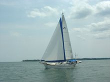
Winds were light, but just forward of the beam, and Rachel moved along nicely on her favorite point of sail. We dropped the fishing line over and relaxed into the lovely rhythm of an easy sail on mild seas.

About 3 miles out of Conception we caught a nice 32” mahi-mahi. Yippee!! Fresh fish tonight! We furled the head sail to slow down, and by the time we landed the fish, filleted it, and cleaned up our mess, it was time to start the engine, drop the main, and pick our way through the coral heads to our anchorage.

Yet another exquisite white sand beach greeted us. The water is as clear or, if possible, even clearer than any we’ve seen so far in the Bahamas. We anchored in 16’ and can still see the bottom in great detail. It’s almost like we’re floating in air.

After we got all settled in we dinghied in and met the Barefootin’s on the beach for one of our favorite activities – a walking exploration of a new island.

Conception Island is a National Trust island. There has been no development here, and fishing, shelling, picking the flowers, etc., are all prohibited. “Take only pictures and leave only footprints.” This island is truly the crown jewel in the Bahamian national park system.

We watch and listen to the birds, smell the ocean air, feel the breeze on our skin, and are grateful for the opportunity to share this incredibly beautiful place with each other. We walk back down the trail, across the beach, get in our dinghies, and return to our boats. Rachel’s crew still has work to do – we’ve invited friends over for fresh grilled mahi-mahi tonight.

After dinner there’s a lull in the conversation as we watch the sun slowly sink into the sea in the west. After a minute or two, Bob says “If this ain’t God’s country, then it must be about 20 yards over that way”.

24 March, 2009

Mr. Knowles

Location: Long Island, Bahamas
Position: N 23 21.521 W 075 08.506


Our trip to the bank and museum were delayed for various reasons, none of which was very important – it’s just difficult to get much done sometimes with our hectic social schedule.

Yesterday we finally hitch hiked down to the bank and the museum in Buckley, about 10 miles south of Salt Pond with our friends Carl and Debbie from Diva.

We paid our $3 non-resident entrance fees and toured the local museum. It’s wonderful, and well worth the price. One of the displays featured various seeds from some of the agricultural products that provided island residents with their livelihoods some time ago. Mark noticed a display of “sapodilla seeds” and asked the museum lady to tell him about sapodillas – what they look like, how they were used, etc. She is an interesting and friendly woman whose husband is the principal at the nearby school.

“Oh,” she says, “I’ve got one right here in my lunch. I’ll show you.” This she proceeded to do. She then divided it up into four parts and gave us each one to try.
We told her we couldn’t bring ourselves to eat part of her lunch to which she said “Oh, it’s okay – I’ve got a whole tree full of them at home and, if I really want one for lunch, I’ll just go pick one from Mr. Knowles’ tree right next door.”


So we let her talk us into eating it – skin and all, the only part not eaten is the seeds. We all agreed that it was delicious – sweet and a bit musky.

We spent an hour or so at the museum, then left to start our trip back to the boats. As we passed the sapodilla tree next door, this little old man walked out toward us and said “I ain’t got no ripe bananas out here, but I got some out back.” We explained that we were looking at his sapodilla tree. He said “Come on over to this here dilly tree! I’ll get you some ripe dillys to eat.”

He then proceeded to climb up into the tree and shake the branches, causing ripe fruit to fall to the ground at our feet. We were afraid he was so fragile that he might come tumbling down with all the fruit. “You just pick them up and come with me.” he said as he climbed back down to the ground.

He herded us all up and took us back into his garden - rows and rows of banana trees, papayas, corn, melons, etc. All of which were growing in little dirt areas that he had been scrabbled out of the rock. It was amazing, and obvious that he'd spent a long time doing a lot of hard work.


He told Debbie, who is petite, that she looked about nine years old. Later, just as we were leaving, he said she looked like she was fourteen. I said "Then she aged pretty quickly, since you just said she was nine" to which he said "Well, time flies when you're having fun."

We learned a bit more Bahamian along the way. He told us that “dem some” means “they’re no relation or friend of mine”. It’s used like “Them boys with knives in Nassau who robs people – (shake head “no”, slowly) dem some.” We also learned about “trans”, as in “I need to get me some trans to get the bananas out to the road so I can sell them.” Trans meaning transportation, of course.

Gentlemen like Mr. Robert Knowles, ladies like the museum lady (maddeningly, none of us can remember her name), and all the other friendly, gracious, and kind people we’ve met on these out islands of the Bahamas set wonderful examples for all of us and remind us to keep it simple and honest.

Humbled once again.

19 March, 2009

Little San Salvador and Long Island

Location: Long Island, Bahamas
Position: N 23 21.521 W 075 08.506


We arrived at Little San Salvador Island (N 24 34.633 W 075 57.282) on the 16th after a wonderful sail from Fernandez Bay, Cat Island. We passed through a “fishing hot spot” as noted in the chart plotter, but unfortunately never even got a nibble.

When we arrived we found a huge cruise ship anchored just off the island, but just as we arrived, she raised anchor and we had this lovely beach to ourselves.

The Holland-America Line purchased Little San Salvador and has turned it into a somewhat Disney-like “island paradise” for their passengers. It seems the ships move from one destination to another at night so the passengers can sleep and not get bored with the travel, then anchor at various “island paradises” for the day so they can enjoy all the amenities.


Things like beaches with big nets around them to keep out the sharks; swimming with the sting rays, also in a big fenced in area – the sting rays have been rendered harmless by removal of their barbs; jet skiing; visiting a not-very-authentic Bahamian church (we knew what it was because of the big “Bahamian Church” sign on the front); relaxing on one of the thousands of recliners that line the beach; horseback riding; or sitting in an open cabana with an air conditioner blowing on you.


One gal we spoke with who works there told us that 3,000 – 4,000 passengers will debark for the day from a single cruise ship – and sometimes there are two cruise ships in port concurrently.

No cruise ships were due in until Friday, so we had a couple of days to explore, walk the trails, and swim in the crystal clear water.

On the 18th we weighed anchor at 2:00 am and had a long 90 mile sail down to Thompson Bay, Long Island. We were really surprised to find over 40 boats here ahead of us. When we were here about this time last year, there were only a dozen or so.


We’re looking forward to hitch hiking to the bank and museum tomorrow.

Fair winds.

15 March, 2009

Cat Island Redux

Location: Cat Island, Bahamas
Position: N 24 19.168 W 075 28.416

One of the pastimes we enjoy when visiting the Bahamian out islands is hitch-hiking. It’s a 2 sided coin, both sides of which are winners. Heads, we get to meet and chat with the local inhabitants. Tails, we get to see parts of the island that we would otherwise miss from the water.

On Cat Island we barely need to hitch hike; cars stop and ask if you need a ride even without flagging them down. We’ve even been just walking and had full cars stop and the driver apologize for not having room! What warm, friendly people! We really love it here.

One day we got a ride from a teacher. He teaches high school math and science, and transferred along with his wife from Nassau, “the big city”. After three years on Cat Island they are now considering accepting a new post on San Salvador, another Bahamian out island 25 miles southeast of Cat. It’s a big decision for them as Cat Island is fairly rural but San Salvador has only one school for all ages and is even more rural and less populated. He told us there are only about 30 children in the entire school. He was an interesting conversationalist, well educated and erudite.
Rachel anchored off the Fernandez Bay resort
Another ride was with a pastry chef who had received his training at a culinary school in the US. After several years working in the States he decided to move home to Cat Island and work as a chef at one of the resorts. We learned about “generation land” from him. Generation land is land that is owned by a family and passes along to the younger generations. It cannot be sold – it belongs to the family in perpetuity. Anyone from the family can homestead on the land but they are not able to secure a mortgage because the property cannot be repossessed if they default. This is why we see so many homes that are under construction. People tend to work and earn money for a while, then work on the home, then work to earn more money – everything “pay-as-you-go”, no mortgages here. Our pastry chef is in the process of building a deli-bakery on his family’s generation land and hopes to be ready to open in a year or two.
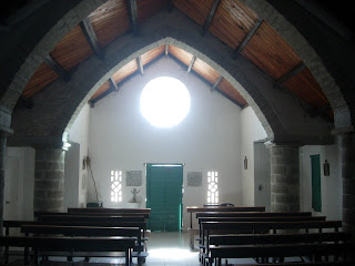
Catholic church New Bight designed by Father Jerome
These are just 2 examples of interesting conversations we’ve had while getting a ride. We usually set off with no specific plan of where we are going. When someone stops and asks where we are going, we say “No place in particular, where are you going?”

One day we decided to hitch hike south toward Old Bight with our friends Beep and Ed from Mid Watch. The lady who picked all four of us up told us there was a “sports day” at the school. We said “Oh that sounds like fun. Will you drop us there?” Often people will drive out of their way to take us where we want to go even though we try to get them to let us out at their convenience.

At any rate, the sports day was great fun. We arrived close to the end and got to see the finals of the junior and senior basketball competitions. Both games were played outside on a concrete court. It was pretty much full contact basketball – not a lot of fouls were called. These kids are tough! Luckily no-one was badly hurt. We dined on macaroni and chicken wings purchased from the food booth, mingled a bit with the locals, and laughed at the antics of some of the spectators. And what high school basket game is complete without a few tailgaters? tailgating

Mark with his entourage watching the basketballAnother day we got a ride north to the end of the road at Orange Creek. Our driver works at the hardware store there. We wandered back down to the next town, Arthurs Town. We saw a little bar/restaurant and went in to get a cold drink and a sit down. We were the only ones there and had a lovely chat with the lady that ran the place. She has a 10 year old daughter who lives in Nassau with relatives so that she can be part of the big junkanoo there. There was a beautiful Junkanoo costume hanging from the wall – oops, we forgot our camera again. I can’t imagine letting a child so young move so far away but it is quite common here in the Bahamas.

Another highlight was “The Hermitage”. In the 1940s and 50s, Father Jerome built a medieval style stone monastery in New Bight on Mt. Alvernia, at 206 ft high, it’s the highest hill in the Bahamas. It’s really quite amazing. He hewed spaces for his interpretation of the Stations of the Cross out of the limestone along the steps to the top. From down below it looks really impressive. Once you get up there, though, you realize that the imposing looking tower is only about twice as tall as Mark!

Hazel BrownAnd this brings us to our last entry in this Khronicle – Ms. Hazel Brown. Hazel is about 80 yrs old and owns a little two-room bar on the shore just north of Smith Bay. Hazel taught us to play Bahamian-style dominos, an integral part of which involves slamming the tiles down on the table “when you got a good play”. Hazel loves to play with all her customers; we wondered if that was why she had opened the bar.

We plan to leave tomorrow for a trip west and a bit north to Little San Salvador for a few days. Then we don’t know where we’ll go. Ain’t cruising grand? gas station Cat Island

Fair winds,

12 March, 2009

Beautiful Cat Island

Location: Fernandez Bay, Cat Island, Bahamas
Position: N 24 19.168 W 075 28.416

Yet another front comes through the Exumas and we head north to Warderick Wells to sit it out. We get great protection there and like the many trails we can walk even during bad weather. We’re getting tired of running back and forth around the Exumas to hide from weather, so, after the front passes and the winds clock around to the north we decide to go somewhere else. This weather is a perfect opportunity to head east to Cat Island on a beam reach. We set off early for the 57 nm trip knowing it’s going to be a long day. The wind and seas are perfect and the sun is shining – we’ve been waiting all winter for a sailing day like this. To make things even better we catch a 35” mahi mahi about half way across. About 45 minutes later we have it aboard, filleted and refrigerated and the cockpit clean again.
mahi in the cockpit
We arrive at Arthurs Town, Cat Island and drop anchor for the night. Over the next days we travel along the west coast of Cat Island passing towns with names like The Lot, Zion Hill, Bluff, Rokers, Gaiters, and Industrious Hill. Landmarks on the chart describe the coast: Pompey Rocks, Big Bluff, Ben Bluff, Lindsays Bluff, and Curry Murry Bluff. We are intrigued by some notes on the chart along the way: “cave”; “brackish wells”; “bat cave”. The coast is mostly ironshore interspersed with high bluffs and the occasional beach making a dinghy landing possible. The waters contain scattered coral heads, so we keep a close watch whenever we’re on the move.

We’ve been at Cat Island for 10 days now and have fallen in love with it. One of the Bahamas more remote islands and for us that is one of its biggest assets. We’ve been the only boat in all of our chosen anchorages until just the last couple of days. The VHF radio is virtually silent, and we’ve been enjoying the quiet and solitude.
view behind the boat
Cat Island has very few anchorages that are protected from the west, one of the main reasons many cruisers tend not to come here. For the first time this winter, however, the forecast is for ten days to two weeks of easterly winds, making it a perfect opportunity for us to explore this beautiful island. The weird part is that we sit at anchor and look off the back of the boat and are looking straight out into the ocean. It’s a disconcerting yet liberating feeling.


Most days we go off exploring by land. We dinghy ashore from wherever we are anchored and start to walk along the road - there’s really only one road that runs the length of the island. Usually within a few minutes, maybe 15 at the most, a car will drive by, stop, and offer us a ride. When asked where we want to go we say “Wherever you are going, we are just exploring”. They usually get a chuckle out of that and say “Well, come on, then!”Armbrister House, and we pile in. We have met the nicest people and learned a lot about life on this small island. After 10 days we have covered most of the northern 2/3 of the island. We’ll give you some highlights of our explorations in the next Khronicle.

Quiet and content,

10 March, 2009

Feeling dinghy

Location: Black Point, Exumas
Position: N24 05.711 W076 24.390

We forgot to tell you a fun story from about a month ago. We were in Black Point along with about 70 other boats and were in the mood for some fun. We decided to get the sail rig out for TrinkaBelle, our 10ft dinghy, and go for a sail. The wind was about 15k, gusting to 20+ and the sun was shining and warm.

Julie took her out first and was weaving through all the anchored boats. She could see envy warring with encouragement on the faces of everyone she passed. (Note: when cruising the amount of actual sailing you achieve is fairly minimal, this is one reason we decided on a sailing/rowing/motoring dinghy. Every time we sail her the other boaters tell us they wish they had one).

At any rate, Julie went honking through the anchorage heeled way over taking water over the side and sitting way up on the gunwale. What fun “Woohoo” she shouted. After she worked her way all the way over to the other side of the bay she headed back downwind to Rachel so that Mark could have a turn.

Suddenly there was a loud creak and the mast tipped over to 45 degrees. The mast step had broken loose, allowing the mast to cant forward much like a drunken knights lance. Yikes!! She hurriedly loosened the lines and got the sail down, rolled into a ball and stuffed under the seat. She had not taken the VHF or a paddle as Mark said he would keep an eye on her in case of trouble. Sheesh she looked around but did not see him coming to her rescue. Darn!!

She floated by a catamaran and hailed the lady on board, "Can you please call my husband on Rachel and have him come and get me?" The lady had Julie throw her a line so that she wouldn’t float away. She came back a minute later and said she could not get Mark on the radio. By this time the dinghy was swinging awfully close to the back of the catamaran and Julie was afraid the leaning mast would damage something. “Just set me adrift” says Julie “I’m afraid I’m going to get the mast caught in your rigging”. The lady really did not want to set her adrift. Just as she was in the process of lengthening the line Mark arrived.

It turned out that Mark had been keeping an eye on Julie but she had disappeared behind a crowd of boats and he’d lost sight of her. He waited a few minutes but when she did not come back into view, he hopped into our small inflatable dinghy and was on his way to find her. He, of course forgot the VHF, too, so didn’t hear the lady calling him. It took him a few minutes driving around the anchorage to find Julie.

It all turned out fine and he towed TrinkaBelle and Julie back to Rachel. After we finally got the sailing rig dismantled it turned out to be a fairly easy repair. We just needed to epoxy the step back in place and make some cosmetic repairs to the deck. That has now been done and we are waiting for a calm day to test it. We unfortunately are not having many of those this year. Julie kindly said Mark can take it out first next time!!

Sorry no pictures yet,