26 June, 2013

Movin' along

Location: near Mount Rushmore, South Dakota
Position: N 43 56.122 W 103 24 043

After 3 weeks, 3890 miles, 6 states, 4 National parks, 21 nights of camping and many scenic highways – we're heading back east.
 
It's been a great trip, not exactly what we'd planned but awesome all the same. Due to limited time to see our granddaughter, Tigerlily, and the cold weather we decided to forgo Canada and instead spent some quality time in the NW US exploring places we haven't been before.

We've had an amazing time and Wanda has performed fantastically. 
 
In our last khronicle we talked about being cold. We'd hoped that this would improve, but unfortunately it didn't. We worked our way up the spectacular California and Oregon coasts, we've never seen coastline quite like it. Huge rocks just sitting offshore, rivers flowing out to sea in competition with the incoming tides and currents cause enormous sand bars which the rivers wind through trying to make their way out into the ocean. 


We decided to head inland and spent the night near Crater Lake National Park. With morning temperatures below 30 degrees F we got up early and headed up to Crater Lake. Due to low clouds making it virtually impossible to see the lake down inside the volcanic crater, high snow banks and ice covered trees it didn't take us long to 'explore' the park. We were cold and definitely underdressed. A stop at a thrift shop in Bend, Oregon was in order where we purchased more warm clothes, socks and an additional blanket. Being in the van at night wasn't too bad but the evenings and mornings when we were cooking and eating outside we just weren't having a lot of fun. 

Good friends who used to live in the Mt Hood/ Columbia River area of Oregon had sent us a list of their favourite hikes, drives and stops. We spent 6 warmer days happily exploring. What a magical place, we see now why they love that area so much. The most spectacular hike took us up through dense forest, suddenly bursting out onto a very narrow path that skirted the slope of Bald mountain. Steep on both sides, one up, the other down, abounding with wildflowers. We rounded a bend and in front of us, so close we could almost touch it, was Mount Hood, shrouded in snow. Breathtaking.


The drive down from Mt Hood National Forest into the Columbia River Gorge took us quickly from dense forest to a lush valley filled with orchards and then we spilled out into the Columbia River. Our friends had said we should stop at every waterfall along the river. We're glad we did as they were all different. A lovely evening spent in Portland visiting with our friends family, they were so welcoming and we were treated to “Pacific Northwest fish and chips” consisting of grilled Columbia River salmon with baked sweet potato home fries – delicious!


Our next stop was Mt. Saint Helens in Washington to see the devastation and change caused by an eruption in 1980. The visitors centre looks right into the cone of the volcano and has a great film depicting the eruption and how the vegetation and wildlife have slowly recovered. We spent the night in a dispersed camping area nearby. Luckily there wasn't another eruption.


Next we took another scenic route past Mt Ranier, then down out of the mountains to the wheat filled high plains of east Washington state and into Idaho. We drove up the Lochsa river for 100 miles winding up through this amazing gorge, a favourite spot for white water rafting and kayaking. It's amazing how much water is transported down these rivers in the spring from the melting snow above. Over the top of the Lolo pass, 10,000 feet elevation into Montana. We certainly have a heart felt respect now for the pioneers who travelled through these mountains on wagons.


Other friends from Missoula, Montana had sent a list of places to visit there. Julie especially loved the carousel. 


After stopping at 3 historic ranger stations and the fire jumpers museum we feel like we've expanded our knowledge and appreciation of forest fire fighters.
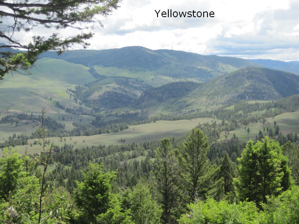
Next it was south and east to Yellowstone National Park in Wyoming, the weather was finally warming up and we were much happier. Yellowstone was the first national park. Created in 1872 it covers 3,472 sq miles. We spent 4 days exploring and didn't even start to see everything. Of course we covered all the high spots Grand Canyon of the Yellowstone, Yellowstone Lake, more “geothermal features” geysers (geysers including Old Faithful and many hot springs, mudpots, and sulphur springs) than you'd want to see in a lifetime. But we also managed to get off the beaten path and enjoyed hiking and wildlife spotting. The amazing part is that even though 3 million people visit the park each year as soon as you get off the main roads and the most popular tourist spots you can really be away from it all and enjoy the park as it is meant to be.


We left Yellowstone and spent another spectacular day driving over the scenic Beartooth Pass back into Montana. The 70 miles of switchbacks took us to an altitude of 11,000 ft, luckily the pass had just opened up the week before. We made many stops to fully appreciate the breathtaking and varied scenery.


Our last stop was Mt Rushmore, South Dakota. Not what you would call a natural beauty but we couldn't pass by without missing this American shrine.

So you can see we've driven a lot of miles, seen amazing and varied scenery and lots of sights. The best part is that we've spent almost 95% of our time on scenic highways, passing through small towns, stopping to see as many scenic views and points of interest, like the Teapot Dome Gas Station in Zillah, Washington, 
 
 
and the St. Ignatius Mission, Montana. 
 
We can't possibly tell you everything but we're posting lots of pictures on the blog for you to enjoy.

The varied scenery, the wildlife and the profuse spring wildflowers have both taken our breath away and filled our hearts with joy.

10 June, 2013

Land Cruising

Location: Near Eureka, CA
Position:  N 40 29.352 W 123 58.725
We've been visiting Julie's son Dan and his family in Redding, CA. Dan is a master mechanic and helped us find our new land yacht “Wanda The Honda".
Wanda” is a 1997 Honda Odyssey van. The old kind with regular opening rear doors (not sliding like most minivans) and regular opening rear windows. This is important for ventilation if you're planning to sleep in the vehicle. She has a little 4 cylinder engine (based on the Accord) that all Dan's friends and all the reviews say is pretty much bulletproof. We don't think we could have found a better vehicle for our use (especially for the price we paid). Everything's a bit tight compared to Rachel, but we think we'll manage just fine.
Yesterday Dan spent an extra 3 hours after work while Mark helped him put on and balance two new tires, change the oil, change the radiator and heater hoses, install new front axles, and generally give Wanda a good going over to make sure she'll make it all the way across North America over the next month or so.
Mark built a raised platform in the back we can sleep on and stow our stuff under. It's in two pieces so we can remove the forward piece and still use the two middle seats for passengers if we need to. We have a cooler, a porta potty, two folding chairs, mosquito screens, rain covers, a galley (pots, bowls, plates, silverware, food, coffee, etc.) in a Rubbermaid container, and a single burner propane stove. Everything we need and we can still sleep in her with all of it stowed. So now we're ready to go.
It's not been all work and no play, however. We managed to make time to relax in Dan's pool, celebrate Mark's 61st and Dan's 30th birthdays, go wake boarding in Dan's boat with several friends, and just generally hang out.
We left Redding yesterday, Sunday, June 9, after celebrating Dan's 30th birthday on the 8th. Our first day on the road was great!! We drove 10 whole miles to Whiskytown State Park and walked up to Whiskeytown Falls in 110 degrees F (whew!). Then we were westbound over the mountains to the coast and Eureka, the town we've heard is the pot capital of the US. Coincidentally, it also happens to be on the shortest route to the West coast from Redding, so don't be getting any ideas as to our motivation for passing through here.
Our first night camping was spent a bit south of Eureka next to a big redwood. We had a great nights sleep and everything so far is working really well. A bit of reorganizing the galley and the stowage area addressed some early “access issues”. Over time we're confident we'll get all the packing and unpacking down to a science.  
The only problem we've had to date is that it is quite a bit colder here on the coast. We're all geared up for summer travel and only brought one pair of jeans and one fleece each. All this cool, damp weather is beginning to get to us. We may have to go clothes shopping.
Chilly but having a good time.


 Banana slugs are rampant here, apparently if you lick them your tongue goes numb - we didn't try it!!

20 May, 2013

Return to the Land of Stuff

Location:  Cocoa Beach, FL
Position:  N 28 21.108    W 080 43.119


After dawdling our way up the Exumas we were faced with a weather 'situation'.  A couple of nice days followed by several days of thunderstorms followed by high winds.  We decided that while we had a couple of good days we'd travel from the Exumas to the Abacos in northern part of the Bahamas, both to make some progress back to the US and because the weather wasn't supposed to be as bad up there.  We ended up  having a lovely overnight sail.

As we approached the Abacos just as the sun was rising we needed to get through a cut we hadn't been through before.  Julie called a big tanker (named “Ocean Energy”), and asked if the cut was straightforward.  Capt. Richie responded, said he was going through the same cut, and told her he'd slow down so we could follow him in...how nice was that!!


We dropped the anchor in Marsh Harbour, checked the weather – of course the forecast had changed for the worse and our bit of nicer weather in the Abacos went away.  So with a great forecast for sailing North and West, we decided to just continue on straight back to the US rather than hide from weather in the Abacos for the next week. So up came the anchor around 11am and we were on our way again for another 2 days and nights.

We poled out both head sails and had a great “wing on wing” trip back. We sailed the whole way and caught our second mahi-mahi of the season - a big 38” bull good for lots of meals.


We arrived at Cape Canaveral just as light was dawning.  Wow - all those lights from the port after 4 months in the Bahamas were slightly overwhelming!  Normally, we would have waited for the sun to come up but we had to get through an opening bridge and into a barge lock before 6:30 or sit and wait until after 9:00.  The bridge and lock do not open during rush hour traffic.  So we increased our speed and entered the port just as it was starting to get light.  We had never been in here before and there was a cruise ship following behind us and a dredging operation taking up half of the entrance channel.  Yikes!  And we were pretty tired, having just been at sea for 3 days and 3 nights.

Everything went well, however,  and we made the bridge and the lock with 5 minutes to spare.  As the lock was closing behind us we heard another boat calling them on the VHF.  It turned out that the lock was going to be closed for construction for the rest of the day.  If we had not made it through when we did we'd have been stuck waiting in Port Canaveral with no place to anchor until 5pm when the lock reopened.  Must have been our lucky day!

After emerging from the lock it was like we were in another world.  We entered the 'Barge Canal' which meanders through several miles of marshland crammed full of wildlife.    It was hard to believe that just minutes earlier we'd been in the middle of a bustling major port.  Now we were seeing cranes swooping, herons dipping into the water and scooping up mouthfuls of fish, meandering dolphins, and wallowing (as they tend to do) manatees.  Plus families of buzzards, ospreys, and many other birds, and jumping fish.  It is a vibrant ecosystem.  Because there was another bridge that was on restriction until 9:30am and there were no other boats behind or in front of us, we were able to just noodle along slowly, enjoying all the wildlife.

Then we were through the last opening bridge and out into the Intracoastal Waterway, the inshore passage up the east coast of the US where boats can travel in relative safety away from the vagaries of the Atlantic ocean.  We went a short way South and anchored at Cocoa Beach next to a high rise bridge  We had been transported back into 'The Land of Stuff'.  Cars and trucks zooming across the bridge, the sound of jackhammers making repairs to the bridge and lots of chatter on the VHF,  what a difference from the peaceful Bahamas!!

And this wasn't all of it.  We enjoyed a quiet relaxing remainder of the day aboard Rachel and made an early night of it. The next morning we headed in to shore to find the grocery store and some fresh vegetables.  We had to walk about a mile up the busy 6 lane highway, passing fast food restaurants, gas stations, shops, shops, shops.

Upon entering the grocery we were on overload.  So much stuff, so many choices, not just cabbage or carrots, which were often our only choices for the last 4 months.  Mmmmm, what to buy? We stacked the cart with yummy vegetables and fruit we had not seen for ages and were salivating and trying to decide which of these delicious choices we'd eat for dinner along with a big grilled slab of our freshly caught mahi.  We're back to the land of stuff where, as long as you have the money....you can buy anything you want.  What luxury!

We've decided to spend hurricane season traveling around the US and Canada a bit.  This Wednesday Rachel will be hauled out of the water and will spend 4 months on land.  We're going to fly to California, buy a truck or a van, and visit family and friends on our way back to the East coast.  It will be strange after 6 years on the boat but we're looking forward to this, our newest adventure.

Missing that clear azure water already,


16 May, 2013

Dawdling


Location: Hawksbill Cay, Exumas, Bahamas
Position: N 24 28.073 W 076 46.170

Our plan to head down to the eastern Caribbean this season was interrupted by several sequential equipment failures. Once we finally dealt with the last of these, we experienced a few weeks of southeasterly winds, not the right direction. Kind of took the wind out of our sails, so to speak. These issues conspired with others to “assist” us in making the decision not to head further south then the Bahamas. Instead we've chosen to head back to the US for hurricane season (July – October).

Because we want to maximize our stay here in these beautiful islands, we're not really in any big hurry to get back. So we're dawdling our way up the Exuma chain of islands, stopping at some of our favourite spots and exploring some new ones.


Bitter Guana Cay, for example. We hadn't been here before, but we'd have friends who say that it's not to be missed – they were right! The whole island is a preserve for the increasingly rare Exuma Iguana. We enjoyed some good walks and spotted lots of these endangered lizards. The largest are reportedly 28lbs and live to be 80 years old! We saw a few of the really big ones, but no pictures as they were far too wary and fast for our trigger fingers!


On the advice of other friends, we stopped at an anchorage off the north end of Pipe Cay. We were all alone here, it was wonderful scenery and a welcome break! We spent our time here taking walks on the beaches and just sitting looking out at the beautiful Bahama water and the stunning sunsets
 

Then there's our perennial favorite, Cambridge Cay. This is, for us, like Cumberland Island in Georgia. A place we never seem to get enough of. If you remember we've been mooring hosts here a couple of times beginning with our first year out. Since then we always like to stop in and check (and maintain, to some degree) the trail we cleared 5 years ago to Honeymoon Beach (has it really been that long?). Snorkeling and swimming in our favorite saltwater swimming pool (the blue hole near our trail head) we also got to see a giant sea turtle with 2 ramoras upside down on it's back...way cool!


At Warderick Wells, the headquarters of the Exuma Cays Land & Sea Park, we visited the south anchorage for the first time. What a beautiful spot! We came in with 15-20 knots of wind and 3-5 ft. seas from the SE – a lumpy but fun sail nearly dead downwind. Once we made the turn into the mooring field, it was like a lake – flat calm and absolutely beautiful. We were the only boat there – what a treat! On a whim we hiked all the way up the island to park HQ and back down again. Not that far in distance (only about 1.5 miles each way), but the 5-hour walk with all the clambering up and down over rocks, walking in soft sand, and negotiating the winding turns of the trail, felt like we'd walked 10 miles!! After the walk, dinner and a nice, relaxing evening on Rachel were just what the doctor ordered. 


Our last stop was Hawksbill Cay, we'd been here before but wanted to spend more time exploring. We would go for a long walk in the morning, before it got too hot. We managed to do a different section of the island each day and discovered hidden trails that we did not know existed. Now we know we can circumnavigate the whole southern half of the island in one walk. Back to Rachel for lunch each day, a bit of a read then off again to snorkel and swim during the hot afternoons.


24 April, 2013

Momentous Day

Location: Stocking Island, George Town, Bahamas
Position: N 23 31.647 W075 45.946  
 
It is an exciting time in George Town. This week is the annual Family Island Regatta , boat race for the local Bahamian sloops. Participants, boats and spectators have been arriving for the last few days. The big mailboats that arrive usually with supplies for the island have been passing Rachel packed to the gills with racing sloops built with care and precision in the traditional fashion on other islands. The town is a hive of activity and anticipation. The men all boasting about their boats, the women dressed to the nines in tight clothes and glamorous hairdos. On the water the Bahamian sloops are setting up and fine tuning their rigs, practicing to make sure everything is working correctly and making sure the crews are familiar with the harbor.
 
 
We attended this regatta 4 years ago and are excited to be here for it again.

Today was the first day of races and Mark was invited to view them, along with a crowd of folks on one of the cruising boats. The plan was to sail around the harbour following the race and getting the best views possible while drinking beer and having fun. Mark had lots of fun as you can see from the pictures. They managed to really get close to the boats making it an exciting afternoon. 


While this was going on Julie was enjoying a relaxing afternoon on Rachel, reading and popping out in the dinghy to watch an occasional race round the mark that was set up, conveniently about a half mile from Rachel. During one of the times of relaxing on the boat a friend, Gail, comes zooming over in her dinghy. She says “Get your bathing suit on and your snorkel. The dolphin's here!” It was not necessary to say more. We'd been waiting for 2 weeks for this to happen. 30 seconds later Julie jumps into the dinghy and off they go. We had seen a dolphin and baby in the harbour and had heard that they would let you swim close to them, but since then we hadn't seen them. Every day we were on the lookout but to no avail. So you see why this was an exciting event. We spent about an hour, cavorting with the mother, we didn't see the baby. We swam so close that we could almost touch her. If we turned and started to swim in a different direction she would turn and follow and then swim up underneath us. Sometimes we would get out of the water onto the boat to get a good view of her from above. But mainly we just took turns being up close and personal. 

Awesome

20 April, 2013

Walkies

Location: Monument Beach anchorage, Stocking Island, George Town, Bahamas
Position: N 23 31.647 W075 45.946 

Yes, we are still in George Town. After waiting more than a month for parts to fix different equipment we were ready to leave but the wind has just not been cooperating. So here we sit. There are certainly much worse places to 'be stuck', however, and after all “we in de Bahamas, mon!”

One of our favorite pastimes here in George Town is walking the paths on Stocking Island. There are many trails to follow, some easy, some rather more difficult. Over the time we've been here, we've settled into a daily routine we call “The Rachel Walk”. We'd like to invite you to come along with us this morning if you like...

We leave Rachel after breakfast and make the 2 minute dinghy trip in to Queens Dock just south of the old Peace & Plenty beach bar. We head inland, past the picnic tables, and bear right to follow the path up to the monument. It's a bit of a climb, so we get our blood pumping first thing – quite invigorating!


Once at the top we sit on a bench and look out across the anchorage and Elizabeth Harbour. You probably hear us saying things like “Look, there's Rachel – isn't she pretty?” “Hey! There's <boat name>! When did those guys come in?” “That one that just came in looks pretty close – I hope they don't bump into us.” “The wind seems to be a bit more south than they were calling for, doesn't it?”

After we catch our breath, we continue east along the monument path toward the beach, but a short way down bear right onto the “Intrepid Path”, a somewhat more vertical down-up-down path for the more intrepid walker. Along the way we climb the second of three hills on our walk and pass a big termite nest hanging in the trees.

The Intrepid Path ends where it joins Marie's Path. We take a left onto Marie's Path and head to the beach. Most of the steep part of the walk is over. There are a couple more “challenging spots” to cover, but except for them you can pretty much relax from here on out.

We continue our walk by meandering north along the beach to where the Monument Path exits on the beach. Following the monument path a short way up the hill (the last of the steep parts of the walk), we bear right and south onto the Cliff Path where we climb the third and last hill of the day. 

This path follows the crest of the dunes for quite a good way, presenting us with gorgeous views of the ocean side of the island. These views are also usually accompanied by a nice cooling breeze, being exposed as they are, to the prevailing easterly trade winds. Good for cooling down after the “climby bits”. There's a nice bench along the way at the juncture with “Nev's Path” where we usually sit for a bit watching the waves surge in and out along the shore.

One feature here is a large crack through the rocks we call “The Surge”. When the waves run up through the crack the resulting pressure pushes a “mushroom cap” of water boiling up over the rest of the wave. Sometimes, when the tide and wind are just right, it also acts like a blow hole, spewing frothy mist high into the air.

Okay, that's enough rest - time to get moving again...

The Cliff Path finally peters out at the beach near where it joins the “Peace & Plenty Path” and “The Nature Trail” near the “Butt Tree”. Don't ask – just take a look at the photo on the blog and you'll see (with only a bit of imagination) how aptly it's named.

We continue north along the beach, looking for treasures along the way, to “The Baths” and the “Julicuzzi”. The Baths is a beautiful basin with a crescent shaped sandy beach on the inside and rocks on the outside. At low tide it's like a giant bathtub. The waves break on the rocks outside but there's hardly a ripple inside the basin.

The Julicuzzi is a fantastic little spot in the south corner of The Baths where one can sit in the water in a small tub-sized sandy basin. At the right tide level the waves break along the shore and a small cut channels water up and over the rocks forming a frothy white waterfall that tumbles down into the basin. It earned it's name because it's Julie's favorite spot along the walk to take a cooling break. 

From the Julicuzzi we make one of three choices. Most often we continue north to the Shoe Tree Trail. Sometimes we backtrack a bit to the unnamed (and unmapped) path we discovered a few weeks ago, and sometimes, if we want one more bit of workout, we continue north along the iron shore to the “North West Path”. Whichever choice we make, we cross the island again and end up back on the Elizabeth Harbour side. We often stop for a rest in the shade at the “The Flip Flop Shop”, a small picnic area complete w/ tiki bar created and maintained by cruisers. 

Regardless of where we come out, we then follow the paths and beaches south along the shore back to the Queen's Dock.

According to our handheld GPS The Rachel Walk is just under 3 statute miles and takes us a little over an hour. Adding in the vertical parts (what Julie calls “the uppy-downy bits”) makes the Rachel Walk a pretty good daily workout for us.

We hope we haven't worn you out. Remember, if you have any energy left we can always go play in the water after lunch!


Mark & Julie
s/v Rachel

11 April, 2013

Cruising

Location: Monument Beach anchorage, Stocking Island, George Town, Exuma
Position: N 23 31.640 W075 45.952 

We've often heard cruising defined as “working on your boat in exotic places”. As much as we'd like to deny it, there's altogether too much truth in that statement. Take the last several months for example...

November, Isle of Palms, SC: install new below deck autopilot. Remove stuff from basement, stow on deck under tarp, crawl around in the aft pointy end of the boat (big thanks to Jim & Betsy for the use of their shop and to Randy & Pat for the use of their truck. You guys rock!).

One month later: Remove tarp, put stuff back in basement, and head south using new autopilot.

One day later: Autopilot quits working.

December, Vero Beach, FL: replace faulty parts on the new autopilot. Remove stuff from basement, place on deck under tarp, crawl around the aft pointy end of the boat. Finally finish new autopilot installation. Remove tarp and put stuff back in basement.

January, Black Point, Exumas: wind generator centrifugal brake breaks – can't use in more than 20 knots of wind until fixed. Contact friends in Vero Beach, Florida who are Bahamas-bound to bring along a piece of stainless steel (among many other things – thanks, Roger & Jane!) so we can have a new part fabricated.

February, Thompson Bay, Long Island: friends w/ stainless delayed, so we go to Thompson Bay to have the wind generator part welded. While we're at it, we also have extra bracing added to autopilot bracket to reduce flexing under load. Do the stuff out of basement, crawl around in the aft pointy end of the boat, stuff back in basement routine again.

February, Red Shanks, George Town, Exuma: anchor windlass quits while anchoring. Turns out the brushes in the motor are shot. Order new parts to be shipped in via air freight.

March, Red Shanks, George Town, Exuma: after spending way too much money on shipping, customs, a customs broker, and local delivery, and spending two frustrating days chasing around after customs, paperwork, customs broker, etc., our windlass brushes arrive. After spending several more frustrating days taking windlass apart, installing new parts, and reassembling, windlass works fine – we can finally haul anchor and move! On our way to Stocking Island we discover new autopilot doesn't work again – now it's blowing fuses. For crying out loud – enough with the autopilot, already!

March, Stocking Island, George Town, Exuma: troubleshoot autopilot w/ manufacturer – he says it's a cable. Same old drill - stuff out of basement, stuff back in basement. Cruising friends have visitors scheduled to come, so we make arrangements to have them bring a new cable to replace the suspected faulty one (Thanks “Jezebell” and “Steve”). New Cable isn't problem. Other cruising friends have visitors coming the following week who bring replacement circuit board (Thanks “Aeolus” and “Hootie Hoo”). That fixes it. Take a test run back out to Long Island for a mini-regatta for which no racing boats show – many of us who were there have taken to calling it the “Long Island Mini Non-Regatta”. Chased back to Georgetown by weather. Scrub exterior teak and apply teak sealer in our spare time.

April, Stocking Island, George Town, Exuma: Sun damaged thread on homemade “stack pack” sail cover begins failing. Remove stack pack, restitch all seams, and reinstall. Luckily, nothing needs to come out of the basement for this job!

Toss in a bunch of other, smaller jobs and you get the picture – we're not just sitting around on a sandy beach contemplating our navels and watching the sun set while sipping wine. However, we ARE in the Bahamas, there ARE sandy beaches and crystal clear water, there ARE happy hours and friends around, there ARE beautiful trails all over the island that we love to walk, and there definitely ARE worse places to be stuck doing boat jobs!

Cruisin' along,


Mark & Julie 

(And thanks to Barefootin' for the photos!)


02 March, 2013

Going Walkabout


Location: Monument Beach, George Town, Exumas, Bahamas
Position: N 23 31.635 W 075 46.052

A cruising boat's dinghy is like the family car. Providing transportation, our dinghy “Belle” allows us to go ashore for entertainment and to shop and exercise. She hauls trash, laundry, fuel jugs, snorkel gear, beach treasures, and us with aplomb. She never complains and is always helpful. We both need and love her.

Every so often we hear on the VHF radio that someone has lost a dinghy. Most of the time what is lost is found, sometimes days later. Every so often it's not found and our hearts go out to the owner who has to cough up a bunch of money for a new dinghy and outboard. Most dinghies are lost because their owners don't tie them up correctly, or they don't maintain the painter (the rope used to tie the dinghy) and it breaks. We hear of the lost little boats and we shake our heads and say “Why can't people just tie their dinghies up properly?”. We chat with our friends about it, tut-tut for a while, and feel a tiny bit superior because we've never lost our dinghy.

A couple of weeks ago we went over to our friend's boat “Hampshire Rose”, for dinner (barbequed ribs – yum!). Rob was in the galley applying an awesome rub to the ribs and Holly welcomed us aboard. We handed her Belle's painter and climbed aboard. Holly tied it off and we proceeded to have fun conversation and a glass (well, maybe a few glasses) of wine.

A few hours later, after dinner, we were relaxing in the cockpit chatting away when Rob said “Hey! Where's your dinghy?”

To which we responded in unison “OH...MY....GOD!!!!”.

Belle had gone walkabout!! It was breezy. It was dark. The last time any of us had noticed “Belle” was about ½ hour earlier. How far could she get in 30 minutes? We couldn't believe it - the dinghys had been happily nuzzled up together back there for a couple of hours with no problems. Oh well – nothing for it - the two guys hopped in the remaining dinghy and went off searching.

This left Julie & Holly back on the boat.....waiting...wondering....worrying. Holly felt really bad as she was the one that tied “Belle” off. Julie was trying to make her feel better saying “I'm sure it will be OK” and “Even if they don't find it tonight I'm sure it will wash up across the harbour and we'll find it in the morning” and “ It can't possibly have gone very far”. But inside she was thinking “OH MY GOD WE LOST OUR DINGHY!!” and “It will float right out of the cut and be lost at sea”.

Meanwhile Mark and Rob headed downwind in Rob & Holly's dinghy. Luckily there was a pretty full moon just coming up. They stopped a few times so they could feel the wind to make sure they were still heading in the right direction and correct for the running tide. Further and further they went feeling less and less optimistic. After about 25 minutes they were nearing the cut that leads out into the ocean. They were almost ready to give up when Rob spotted her! There was “Belle”, bobbing around on top of the water about 200 feet off to their left, just barely within visual range. It was unbelievable luck to have found her – thank goodness for that moon!

They picked up her painter and towed her back to the boat. Needless to say, Mark tied her up when we got back. We never did figure out what had happened. Holly is an experienced cruiser and certainly knows how to go about tying a bowline. All we can figure is that we were all excited to see each other, it had been a while since we'd last been together, and the fun of the reunion must have clouded her mind for a moment. However it happened we were ecstatic to have our “Belle” back in the fold.

From now on we're tying off Belle ourselves and we'll let our friends tie off their dinghies when they come to Rachel to visit, too. Not because we don't trust our friends but because if something does happen it's best if it's your own fault and not someone else's.


The next day we took “Belle” to shore and cleaned her up nice and pretty, to show her our appreciation for her safe return and to encourage her to want to stay with us.

Going a bit dinghy,