Location: Somes Harbor, Mt. Desert Island, ME
Position: N 44 21.623 W 068 19.649
Mmmmm…blueberries. And not just any blueberries. Low bush Maine blueberries. Have you ever had any of these? They’re pretty small – a large one runs about 3/8” in diameter and most are about 1/4". But the flavor. Oh my.
We couldn’t have timed our visit to Mt. Desert Island and Acadia National
Park any better if we’d planned it. It’s the height of blueberry season here and the hills are covered with the delicious little blue orbs. To top it off, every time we hear the local pronunciation of the island’s name (“dessert” not “desert” – the emphasis being on the second syllable) our mouths begin to water in anticipation of the mountains of dessert we’ll soon be making.
Mt. Desert Island is home to a majority of the land in the Acadia National Park, one of the smallest, yet most popular parks in the national park system. More than 3 million visitors come to Mt. Desert Island every year. One of our cruising guides says “People come from everywhere to see this beautiful island, this granite-hard, fog-softened, primeval meeting place of land and sea.” Luckily, most of these tourists arrive by car (and seem to spend most of their time there). This leaves the mountainous hiking trails relatively uncrowded.
Our home base is in Somes Harbor at the northern end of Somes Sound, the fjord that nearly bisects the island. We’ve been anchored here for four days so far, and are looking forward to spending a few more days here. From Rachel, we can row the dinghy in to the public dock and walk up the short road past some beautiful gardens and fields full of wildflowers to the main road. There we stand until one of the free buses that run every hour to Bar Harbor passes. We flag it down and ride it in to town. From the village green we can take any of 7 different bus routes around the island and through the park.
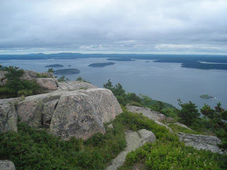
Yesterday we got together with our friends on “Osprey” and went for a hike in the park. After some discussion with a couple from a neighboring boat who have come here for years, we decided upon the Bear Brook Trail which runs north-south and crosses Champlain (1058 ft.), Halfway, and Gorham (525 ft) Mountains. It’s a 4 1/3 mile trek rated as “moderate” in the trail guide. It turned out to be just right. We got to do a bit of scrambling, a lot of up-and-down hiking over rocks (good workout for the knees), and some forested paths that took us along the banks of a beaver pond. Along the way we found patch after patch of blueberries.

At around noon, after we’d crested the top of Champlain Mountain, we stopped, rested, and ate our picnic lunches. After our lunch break we started collecting berries as we walked along. Kayo and Birdie, the “Osprey” kids, would run on ahead and find the “Oh my gosh! The mother lode!!” berry patches. The adults would catch up and all six of us would spend a few minutes harvesting the biggest and bluest berries we could see. This continued on and off for the next hour or so until we’d collected several pints. For the remainder of the walk any berries picked went directly into our mouths. You could tell by all the blue tongues that we got our antioxidants for the day!
Just as we were running out of steam we arrived at the end of the trail. Happy, tired, and a bit achy, we lolled around on the shore side of the road park loop watching the ocean waves roll in until the bus came by to take us home.
In all, Rachel’s crew collected about two pints of berries. All that remains now is for us to decide how to prepare them. There are so many choices. To paraphrase Bubba in the movie “Forrest Gump”: “You got blueberry buckle, blueberry cobbler, blueberries in yogurt, blueberry muffins, plain old blueberries, blueberry pancakes, blueberry trifle, blueberry pie, blueberries and cream, blueberry duff, blueberry scones, blueberry bread, blueberries on cereal, blueberry waffles, blueberries in custard, blueberry tarts, blueberry twists, blueberry syrup, blueberry donuts, blueberry cupcakes, blueberry ……….”
Position: N 44 21.623 W 068 19.649
Mmmmm…blueberries. And not just any blueberries. Low bush Maine blueberries. Have you ever had any of these? They’re pretty small – a large one runs about 3/8” in diameter and most are about 1/4". But the flavor. Oh my.
We couldn’t have timed our visit to Mt. Desert Island and Acadia National
Park any better if we’d planned it. It’s the height of blueberry season here and the hills are covered with the delicious little blue orbs. To top it off, every time we hear the local pronunciation of the island’s name (“dessert” not “desert” – the emphasis being on the second syllable) our mouths begin to water in anticipation of the mountains of dessert we’ll soon be making.
Mt. Desert Island is home to a majority of the land in the Acadia National Park, one of the smallest, yet most popular parks in the national park system. More than 3 million visitors come to Mt. Desert Island every year. One of our cruising guides says “People come from everywhere to see this beautiful island, this granite-hard, fog-softened, primeval meeting place of land and sea.” Luckily, most of these tourists arrive by car (and seem to spend most of their time there). This leaves the mountainous hiking trails relatively uncrowded.

Our home base is in Somes Harbor at the northern end of Somes Sound, the fjord that nearly bisects the island. We’ve been anchored here for four days so far, and are looking forward to spending a few more days here. From Rachel, we can row the dinghy in to the public dock and walk up the short road past some beautiful gardens and fields full of wildflowers to the main road. There we stand until one of the free buses that run every hour to Bar Harbor passes. We flag it down and ride it in to town. From the village green we can take any of 7 different bus routes around the island and through the park.
Yesterday we got together with our friends on “Osprey” and went for a hike in the park. After some discussion with a couple from a neighboring boat who have come here for years, we decided upon the Bear Brook Trail which runs north-south and crosses Champlain (1058 ft.), Halfway, and Gorham (525 ft) Mountains. It’s a 4 1/3 mile trek rated as “moderate” in the trail guide. It turned out to be just right. We got to do a bit of scrambling, a lot of up-and-down hiking over rocks (good workout for the knees), and some forested paths that took us along the banks of a beaver pond. Along the way we found patch after patch of blueberries.

At around noon, after we’d crested the top of Champlain Mountain, we stopped, rested, and ate our picnic lunches. After our lunch break we started collecting berries as we walked along. Kayo and Birdie, the “Osprey” kids, would run on ahead and find the “Oh my gosh! The mother lode!!” berry patches. The adults would catch up and all six of us would spend a few minutes harvesting the biggest and bluest berries we could see. This continued on and off for the next hour or so until we’d collected several pints. For the remainder of the walk any berries picked went directly into our mouths. You could tell by all the blue tongues that we got our antioxidants for the day!
Just as we were running out of steam we arrived at the end of the trail. Happy, tired, and a bit achy, we lolled around on the shore side of the road park loop watching the ocean waves roll in until the bus came by to take us home.
In all, Rachel’s crew collected about two pints of berries. All that remains now is for us to decide how to prepare them. There are so many choices. To paraphrase Bubba in the movie “Forrest Gump”: “You got blueberry buckle, blueberry cobbler, blueberries in yogurt, blueberry muffins, plain old blueberries, blueberry pancakes, blueberry trifle, blueberry pie, blueberries and cream, blueberry duff, blueberry scones, blueberry bread, blueberries on cereal, blueberry waffles, blueberries in custard, blueberry tarts, blueberry twists, blueberry syrup, blueberry donuts, blueberry cupcakes, blueberry ……….”